GPS mapping program could improve town’s services
Published 9:22 am Thursday, December 19, 2013
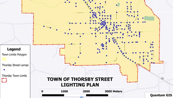
Lit up: This example of a map produced by the QGIS program shows where street lights are located in Thorsby.
A “geographic information system” could help Thorsby better provide services to its residents.
Town Councilman Glenn Littleton is helping the town implement QGIS, a free and open source desktop GIS application, which could allow the town to map street lights, the sewer system, fire hydrants, water valves, water meters and more.
“I’m sure there are a lot more projects we’ll use it for,” Littleton said.
Littleton, who professes a love for maps, downloaded the program on his personal computer and worked with it to see what benefits it could provide the town.
“It’s easy to download, but there’s a big learning curve,” he said. “I was almost ready to give up on it, but with the power of YouTube… you can pull anything off YouTube. Things started clicking.”
With a better understanding of the program, Littleton is convinced it could help town leaders.
The program uses Global Positioning System to map entered locations. Details, or “attributes,” about the locations can also be entered.
So, Thorsby’s Fire Department could enter GPS coordinates of all the town’s fire hydrants, plus relevant information such as water flow capacity for each hydrant. Then, say a large building catches fire. Firefighters could quickly search the system for locations of hydrants that would allow a flow large enough to battle the blaze.
“It’s not just for drawing maps,” Littleton said.
A neglected cemetery in the town highlights another potential use for the system. Littleton said the cemetery off Highway 31 in the northern part of town has been deemed town property since there is no other owner listed. The QGIS program would allow the town to plot grave sites along with names of those buried at the cemetery before the headstones become illegible.
Littleton said he envisions several town computers being equipped with the program. All would have access to the same information.
GPS mapping wouldn’t begin for another couple of months, once trees have shed all their leaves, improving the accuracy of the plotting.
In discussions about the program, Town Council members have expressed favorable opinions.
The council would likely not have to take any action for departments to begin using the program since it’s free.
Expenses could be involved down the road, however, if the town decided to invest in a GPS receiver, a mobile device used to determine coordinates, or a plotter, a “printer” of sorts that can produce large-scale and detailed maps.
Even without a plotter, Littleton said he thinks the program would benefit the town.
“It’s a good opportunity,” he said. “This is the technology that’s out there, and it’s free.”
More Editor's pick
SportsPlus
How to Watch MLB Baseball on Friday, July 26: TV Channel, Live Streaming, Start Times
The Cleveland Guardians and the Philadelphia Phillies take the field for one of many compelling matchups on the…
How to Watch the Braves vs. Mets Game: Streaming & TV Channel Info for July 26
Francisco Lindor and the New York Mets will meet Marcell Ozuna and the Atlanta Braves on Friday at…
Braves vs. Mets: Betting Preview for July 26
On Friday, July 26 at 7:10 PM ET, the New York Mets (54-48) host the Atlanta Braves (54-47)…
Atlanta Falcons vs. Minnesota Vikings Week 14 Tickets Available – Sunday, December 8 at U.S. Bank Stadium
The Atlanta Falcons (0-0) visit U.S. Bank Stadium on Sunday, December 8, 2024 to challenge the Minnesota Vikings…
Atlanta Falcons vs. New Orleans Saints Week 10 Tickets Available – Sunday, November 10 at Caesars Superdome
On Sunday, November 10, 2024, the Atlanta Falcons (0-0) hit the road for an NFC South bout against…
